British Columbia · Flagship Project · 100% Owned

Kliyul

Significant resource that remains open; multiple untested targets

334.1 Mt

at 0.33% CuEq¹, inferred

2.42 Blb

contained CuEq¹, or 5.7 Moz AuEq¹

92 km²

land package, 100% owned

~20,000 m

drilled since 2021

Overview

A Resource at One Target.
A Trend of Untested Ones.

Kliyul is Pacific Ridge’s flagship copper-gold porphyry project in the Quesnel Terrane of north-central British Columbia. The Kliyul Main Zone hosts an inferred mineral resource of 334.1 million tonnes at 0.33% copper equivalent¹, containing 2.42 billion pounds CuEq¹ or 5.7 million ounces AuEq¹.

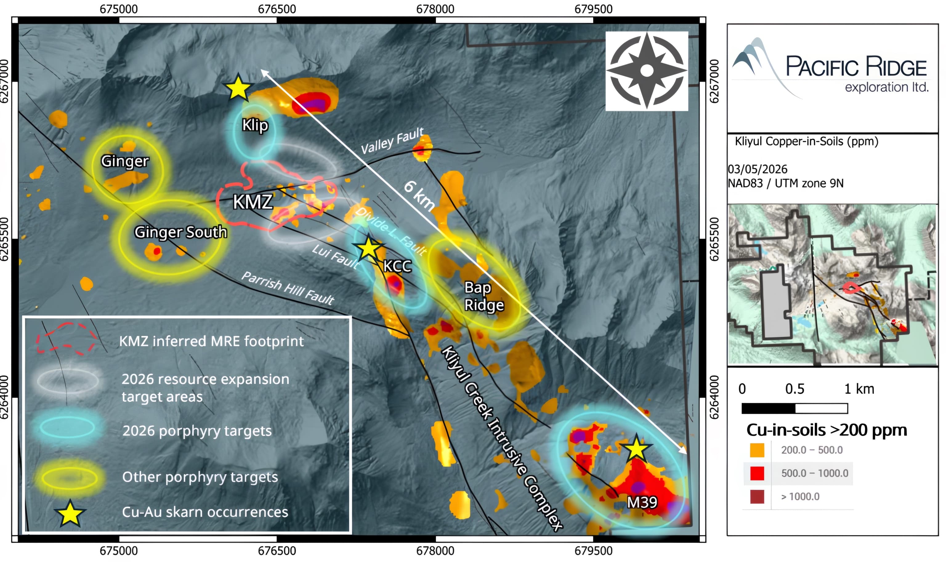
Although drilling to date has focused almost exclusively on the Kliyul Main Zone, multiple untested targets remain along a six-kilometre porphyry copper-gold trend characterized by favourable geology, geochemistry, alteration, and geophysical signatures. While the Kliyul Main Zone remains open for expansion, the 2026 drill program will prioritize the M39 target, a high-priority target that has never been drill tested.

Investor Presentation
Kliyul copper-in-soils map showing the KMZ resource footprint and untested targets along the six-kilometre trend
MULTIPLE TARGETS ON SIX-KILOMETRE-LONG TREND

Drill Highlights

What the Main Zone Delivers

KLI-25-070

289 m of 0.77% CuEq² or 1.15 g/t AuEq³

within 489.8 m of 0.56% CuEq² or 0.84 g/t AuEq³

Open

Kliyul Main Zone

The Kliyul Main Zone deposit remains open

~2,500 m

planned in 2026

prioritizing the never-drilled M39 target

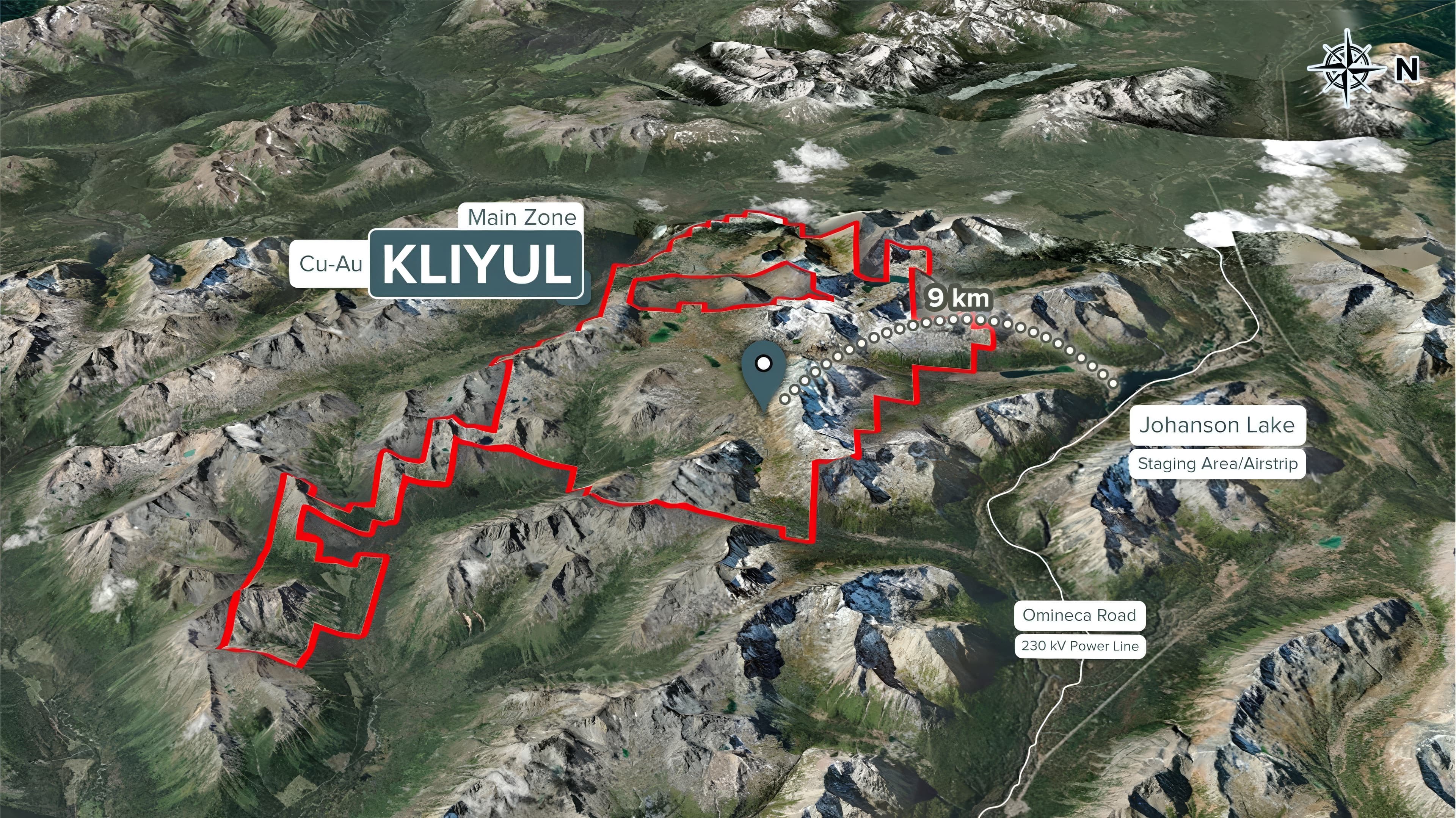
3D terrain view of the Kliyul claim block with the Omineca resource road and power line to the east
~8 KM TO THE OMINECA RESOURCE ROAD & 230 KV POWER LINE

Location & Infrastructure

Practical Logistics

  • Approximately eight kilometres to the Omineca resource road and a 230-kilovolt high-voltage power line.
  • Johanson Lake staging area and airstrip nearby, with camp established on site.
  • In the Quesnel Terrane, the belt that hosts Copper Mountain, Highland Valley, New Afton, Gibraltar and Mount Milligan.
  • Exploration agreement in place with Takla Nation covering Kliyul and RDP.

Complete Project Record

Technical Detail & History

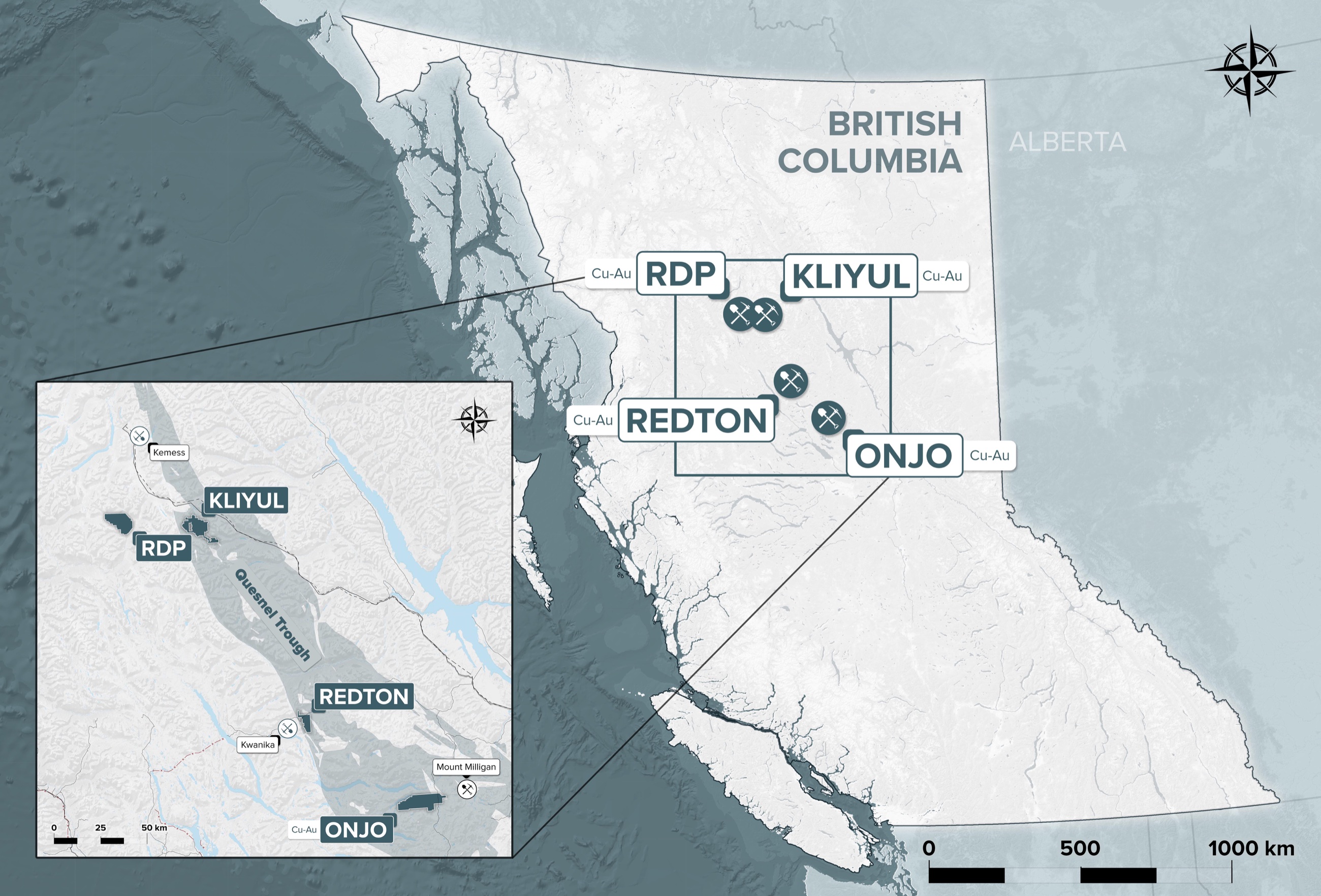
British Columbia locator map showing Pacific Ridge's Kliyul, RDP, Redton and Onjo projects
Pacific Ridge British Columbia project locations
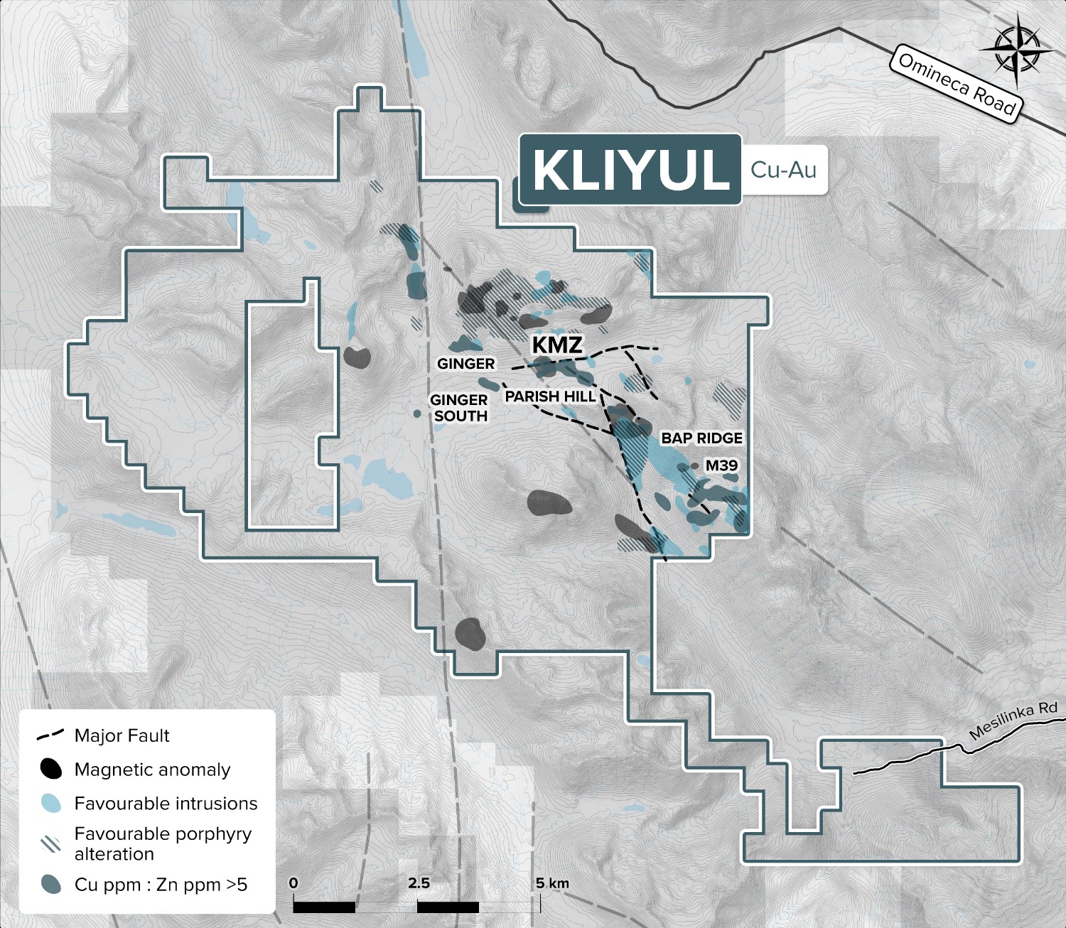
Detailed Kliyul claim map
Kliyul claim map
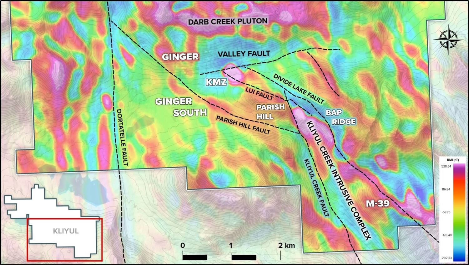
Kliyul porphyry target map
Six-kilometre target trend

01

Geological Setting

Kliyul is situated in the northern Quesnel Terrane, an island arc formed along the western North American continental margin. The project is underlain by Late Triassic Takla Group volcanic, volcaniclastic and sedimentary rocks, including the Kliyul Creek and Goldway Peak units.

Four principal intrusive phases occur in and around the project: the Upper Triassic Kliyul Creek Complex, a Triassic-to-Jurassic monzonite porphyry, the Early–Middle Jurassic Darb Creek tonalite, and Lower Cretaceous Osilinka stocks.

02

Mineralization

Porphyry copper mineralization typically occurs as veined and disseminated chalcopyrite with lesser bornite. Common vein types include chlorite-epidote-pyrite, quartz-sericite-anhydrite-calcite-pyrite and quartz-chlorite-magnetite-pyrite assemblages.

Mineralization is most commonly hosted by andesite and volcaniclastic andesite, with feldspar porphyry and equigranular diorite also acting as hosts. Higher copper and gold grades correlate with magnetite-cemented breccia, increased vein density and the presence of bornite.

03

Targets and Historic Work

Six porphyry targets are identified across the six-kilometre trend: Kliyul Main Zone, Bap Ridge, Ginger, Ginger South, M39 and Parish Hill. Before Pacific Ridge’s 2021 program, 33 holes totalling 5,524 metres had been drilled at KMZ.

04

2021 Drill Program

Pacific Ridge completed 1,544 metres in three holes, KLI-21-036 through KLI-21-038.

  • All three holes returned significant copper-gold mineralization and extended KMZ westward and at depth.
  • KLI-21-037 returned 316.7 m of 0.79% CuEq² or 1.17 g/t AuEq³ within 566.7 m of 0.51% CuEq² or 0.75 g/t AuEq³.
  • Selected intervals returned values up to 4.0% copper and 5.8 g/t gold; bornite in KLI-21-036 and KLI-21-038 provided an encouraging vector toward the porphyry centre.

05

2022 Exploration Program

The program included 7,014.7 metres in 12 holes, 27 line-kilometres of IP, 423 line-kilometres of airborne magnetic and radiometric surveying, MVI modelling, 257.5 line-kilometres of LiDAR, geochemical modelling, mapping and sampling.

  • Drilling expanded the interpreted KMZ mineralized body to approximately 600 m east-west by 350 m north-south by 600 m vertically.
  • KLI-22-050 returned 328.0 m of 0.64% CuEq² or 0.95 g/t AuEq³ within 526.0 m of 0.49% CuEq² or 0.73 g/t AuEq³.
  • Work showed that KMZ remained open in all directions and at depth, confirmed key fault controls and provided vectors toward a possible porphyry core west or southwest of KMZ.

06

2023 Drill Program

Pacific Ridge completed 10,284 metres in 19 holes, the largest program completed at Kliyul at that time.

  • Six contiguous fault blocks were tested across an area approximately 1,300 m east-west, 600 m north-south and as much as 650 m deep.
  • Three holes tested Ginger, Ginger South and Parish Hill, up to 1.5 km from KMZ.
  • KLI-23-068 returned 110.0 m of 0.97% CuEq² or 1.44 g/t AuEq³ within 455.8 m of 0.43% CuEq² or 0.63 g/t AuEq³.
  • KLI-23-069 returned the deepest mineralized interval then encountered at Kliyul; interpreted extents reached approximately 760 m by 600 m by 650 m.

07

2024 Exploration Program

  • A 541 line-kilometre airborne ZTEM survey covered 85% of Kliyul.
  • Results strengthened the interpretation of a mineralized quartz-diorite porphyry stock north of KMZ and outlined a possible 700 m KMZ–Klip corridor.
  • The working model treats KMZ as one mineralized centre within a larger, zoned porphyry system.

08

2025 Drill Program

  • Two holes totalling 1,287 metres were completed.
  • KLI-25-070 returned 289.0 m of 0.77% CuEq² or 1.15 g/t AuEq³ within 489.8 m of 0.56% CuEq² or 0.84 g/t AuEq³.
  • KLI-25-071 returned 91.0 m of 0.47% CuEq² or 0.70 g/t AuEq³ within 421 m of 0.24% CuEq² or 0.35 g/t AuEq³ and extended mineralization 110 m west of KLI-23-068.